2) Ocean Currents
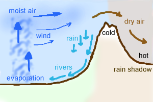
3) Relief/ Rain Shadow
4) Prevailing Wind
5) Continentality
1. Global Atmospheric Circulation
LATITUDE
- At the equator, the sun is directly overhead and thus more concentrated, insolation.
- Meanwhile at higher latitudes the sun's energy is spread out due to the curvature of the Earth.
- At the poles the solar radiation has to pass through a greater amount of atmosphere due to the curvature of the Earth.
- This increases the potential for reflection and scattering in the Earth's atmosphere, reducing incoming insolation.
TRI-CELLULAR MODEL

Flash flooding:
- Local low pressure system prevented from rising due to the general high pressure system. This means that the climate is stable and there is no rain.
- The local low pressure occasionally bursts through the global scale high pressure system. This causes local flash-flooding on a large scale and due to the limited interception and baked ground the amount of surface run-off is never decreased.
E.G. Chicama, Peru has a mean annual precipitation of 4mm but 394mm during a thunderstorm.
2. Ocean Currents
- Balances variances in insolation due to latitude.
- Where a cold ocean current passes a land mass it will lower coastal temperatures.
- They reduce the amount of precipitation as the cold ocean cools the air above and thus reduces its capacity to hold moisture.
Advection fog= Occurs where the cold air from above the current as blown onshore by wind. When it meets the warm air above the ground, causing it to cool and condense, creating fog.
3. Relief/Rain Shadow
- Mountain ranges block the passage of rain-bearing clouds.
- Moist air is forced to rise over mountains, leading to RCC, thus reducing moisture available for rain in the lee of the mountains (i.e. rain shadow)
- The descending air is compressed, warming it and reducing chances of rain.
4. Prevailing Winds
- Many hot arid areas are located where the prevailing winds blow from land to sea and therefore carry little moisture.
5. Continentality/Distance from the sea
- More landlocked a country/area is the more extreme the temperature ranges between seasons (gain and lose heat rapidly)
- However areas closer to the oceans have narrower temperature ranges as the water acts as a buffer. Areas like this are known to have 'high oceanity'.
Seasonal Rainfall:
ITCZ:
(Inter-Tropical Convergance zone)
Fact= The Earth is tilted relative to the sun by 23.5°.
In June (Summer)
- The Northern hemisphere is tilted towards the sun.
- The most intense heating (i.e. sun directly overhead) from the sun moves to the north of the equator towards the Tropic of Cancer.
- This causes the ITCZ to move North.
- The opposite occurs in December.
No comments:
Post a Comment